Looking for some help here! My projects are all geographic ie criterion for each is that an observation fall within a defined area. One of them included a quite complex area boundary which I kept meaning to go back and map more accurately. I have amended that map boundary before, through the editing process.
I went into the project the other day intending to sort the map but found no map came up when editing ‘location’. I suppose I can just re-do the map and try to get it correct this time. This action was prompted by posting an observation seen within the project area but which is not coming up as being in it. I’m wondering toil I can find and edit the map currently in use for the project. Title: Great Trossachs Forest.
Not “pedestrian”! Maps are one of the problem areas of the site in its current incarnation. I’ll have a look at one of mine and see if I can do it.
Updated: I went into my Great Fen project, selected “Summary” and “Edit”. On the "Locations page I was able to edit the map. I didn’t try to save it, though.
Thanks for taking the time. So I did the same for my Trossachs project and there is no polygon appearing on the map that I can edit. The location part of the edit sequence shows a red X, so I’m thinking my map is gone. I’m going to shift a couple of observations by a km or so just to see if the map is operating at present, as it clearly has done fairly recently. The other thing I’ll do is check another project and see if the maps appear and are editable.
Update: have checked other projects and they show a project map on the summary page, which my Great Trossachs Forest one does not. I moved an observation from the other day (buzzard) up the hill a bit and it was included. I find this hard to understand - no map on summary page, no map to edit at location and location marked red X, so how can the project identify the buzzard as being in the delineated (previously!) area???
I’ll just have to set aside some time to redo the map, this time, I’ll try to do a better job from the start!
I would like to be able to give you the polygon so you can just re-upload it but despite large numbers of requests to programmers, upload of polygons is still not possible. Also the data are stored in a rather horrible non-standard format in the database so currently not able get out and put in GIS and view it. I could try to give you the points in the database’s rather horrible format if you want but strongly suspect that would not help. These items are things we are working on though so at some stage it should be possible to at least output the polygons in a friendly format.
Hi there Thanks for responding, miked. I am wondering if I can just create a new project for the Great Trossachs Forest, making a new map and leaving the IT to gather the observations as before? I could then delete the existing one. I would like anyone who finds the project to know where the GTF is. That seems reasonable to me, but let me know if it’s not! Mags
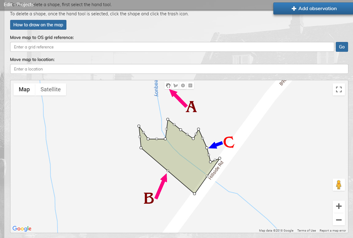
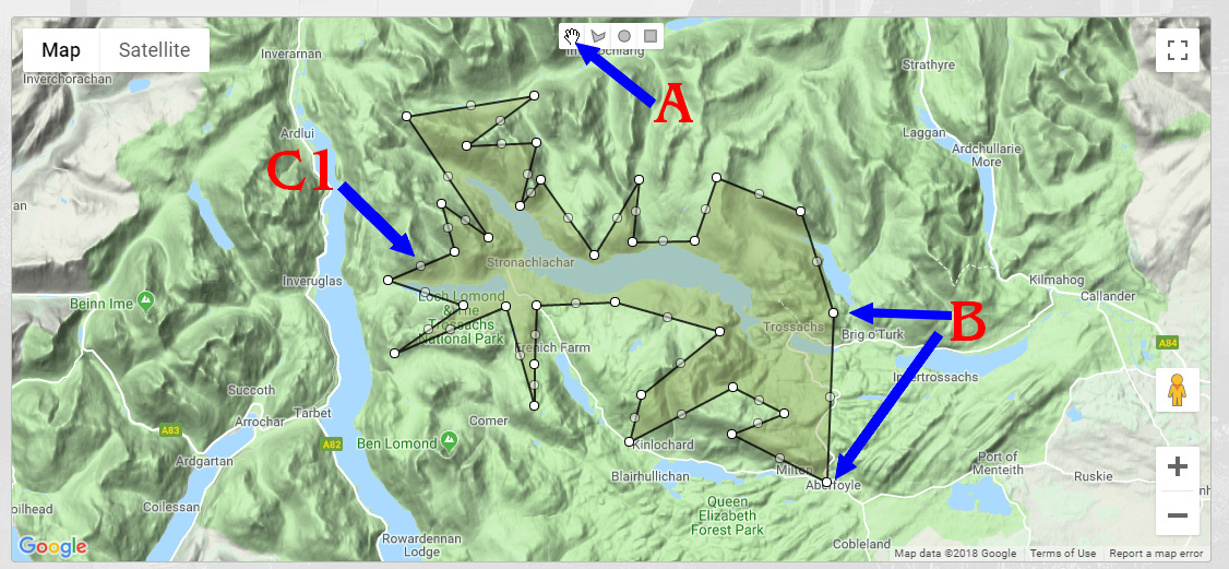
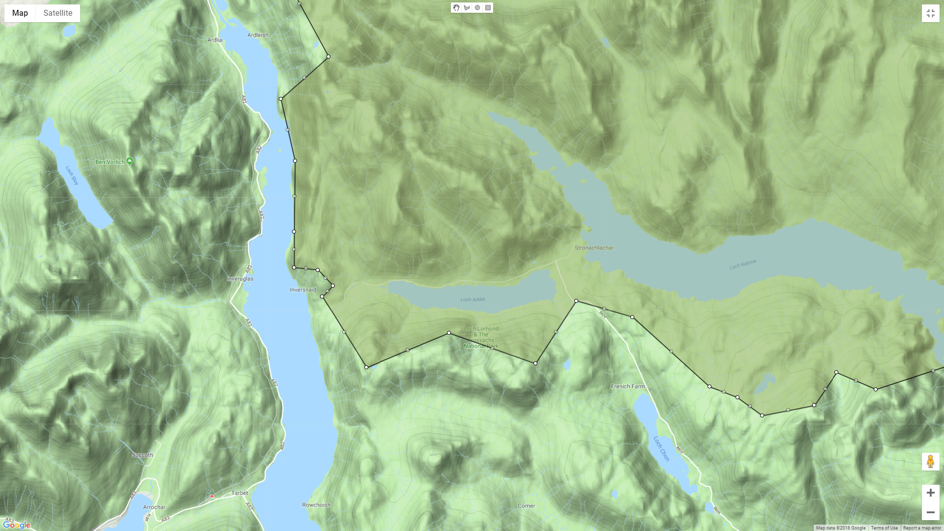
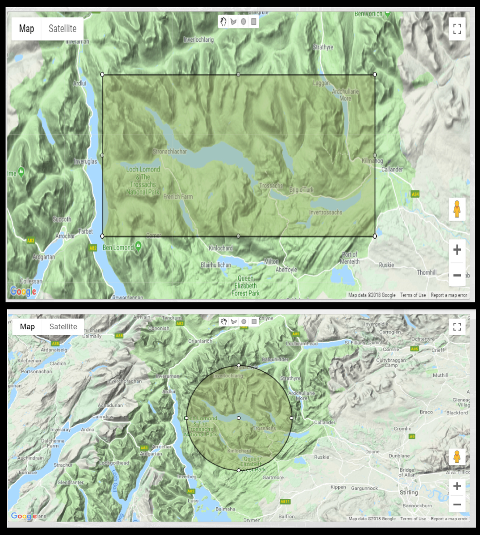
Click on A, grab a B and drag it (inwards or outward) to a very accurate place on the Trossachs Map. Doing so produces subsidiary handles each side of a B - see C.
Don’t do too much at any one time and save (Agree & Update) the Map often before you ruin it. If you mess up any one time just don’t save and have another glass of wine.
I may be able to help more - I have never done a complex map only used Tags (trossachs1) for collections MUCH easier!
You are a wonder, thank you so much for taking the time to do this. I think you correctly assessed that it seemed to me a bit of a pain to redo the map get the boundary correct, and you have encouraged me to tackle it, which I will do when time allows. (But almost all of what fills my time is enjoyable.) My other projects have map outlines with less complexity, such as Loch Ardinning. I am fortunate in having a huge screen on this iMac and also some other maps at high res of TGF so I expect I’ll get there in the end. Would like to have your recommendation on what should be in the bottles!!
I really appreciate the support, I was pretty nonplussed to discover this project map mystery. Mags
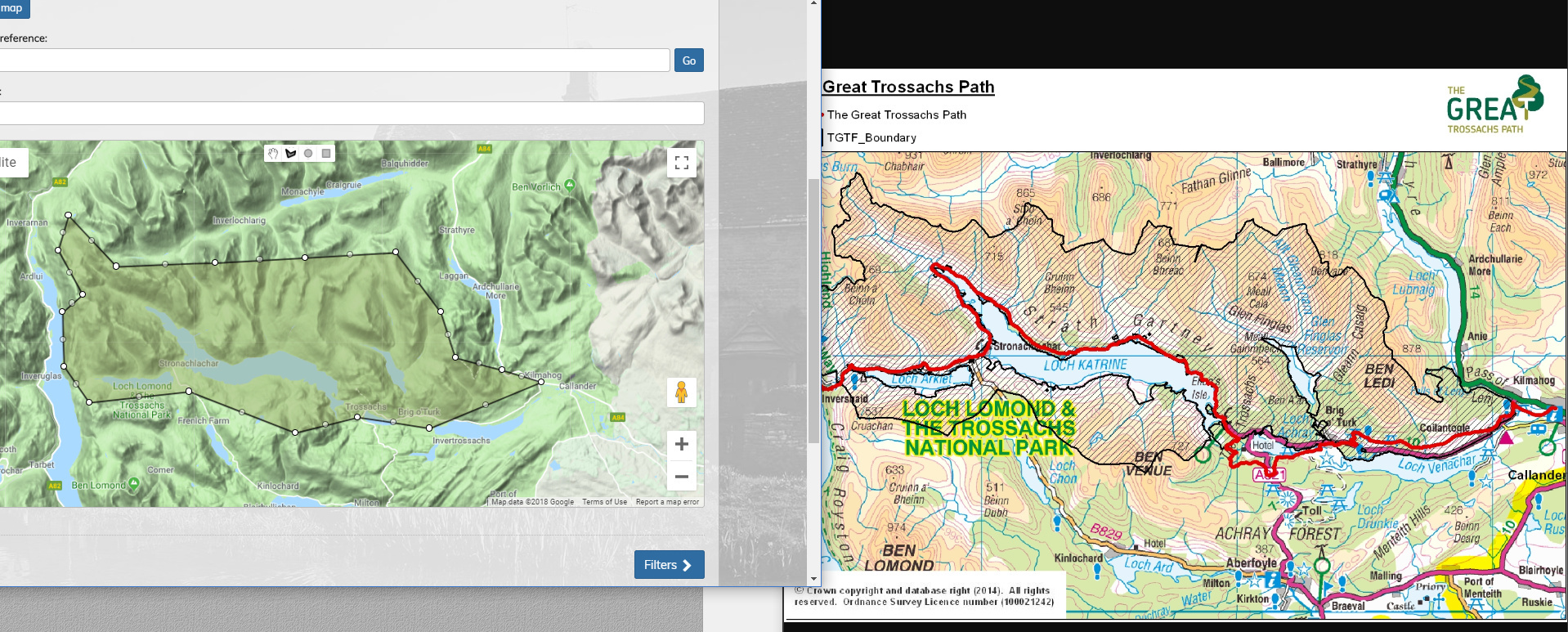
I then found it more difficult to do the details because neither map is actually detailed enough, I think you need the OS !:25000 Map beside you with marks on it, so that you can update very small sections at a time, saving or discarding OFTEN.
As you can see the iSpot map is not really detailed enough for this, so you will never get it precise (I also tried it in Satellite mode)
Thanks for the tutorial here, the save often is particularly useful and making sure you are using the correct tool all the time otherwise the whole shape can move. I had several goes at doing the outline for Switzerland for projects relating to that country and it is a real pain, suspect a rule of ‘good enough in 15 mins’ might be an idea rather than spending many hours on the exact boundary. Perhaps look at how many observations there are near the boundary to see if getting it more accurate is worth it, in some cases it may be worth spending more time.
Oh yes, grabbing the ‘shape’ and dragging it by accident is not something you will do many times, considering the difficulties it creates!
I think we should practise this before embarking on a real boundary. It is easy to start a new project, play with the Location Map and chuck it all in the bin after 15 mins. Do that three times before embarking on a real one. I did learn a lot doing the maps above.
Many thanks for the tutorial, encouragement and advice, the ‘saving often’ tip proved a sanity saver! I am not entirely content with the map, but I believe it’s more accurate than the one that was lost. And I can still type straight - almost!
Yes, lifting details from respected sources such as the SNH website (see https://sitelink.nature.scot/site/10503 for this NNR) would be great, and others might want to investigate their special place such as an SSSI through iSpot so that would be a good facility.